Better Together: Why Desktop Research and Field Precision Both Matter in Utility Management
)
The planning phase and field execution phase of utility work require fundamentally different tools.
4M Analytics recently published an article comparing their AI-driven utility mapping platform with traditional manual research methods. They make compelling points about the delays, gaps, and inefficiencies in conventional records research.
They're solving a real problem.
But there's an important distinction worth exploring: the difference between knowing utilities might be present versus documenting exactly where they are.
Both capabilities matter. And they work best when used together.
What Desktop Research Does Well
4M Analytics positions their platform as "Utility AI Mapping"—aggregating records, permits, imagery, and geospatial data to create comprehensive utility maps for planning and design phases.
This addresses genuine pain points in infrastructure projects.
Manual records research is slow. Waiting weeks or months for utility owners to respond creates project bottlenecks. Piecing together fragmented data from multiple sources in different formats burns valuable time.
4M's platform solves this by providing instant access to aggregated utility information across hundreds of data sources. For planning, bidding, and preliminary design, this speeds up workflows dramatically.
Their customer examples show 7-month reductions in research time and 50% cuts in field investigation duration.
Those are meaningful improvements for project teams trying to scope work, identify risks, and develop preliminary designs.
The value proposition is clear: know what utilities are likely present before you mobilize field crews.
This helps teams avoid surprises, plan safer excavation approaches, and develop more accurate project budgets.
Where Precision Becomes Critical
But here's where the distinction matters.
Subsurface Utility Engineering (SUE) and utility locating require precision that desktop research—no matter how comprehensive—cannot provide.
When you're marking utilities for excavation, "likely present in this corridor" isn't sufficient. You need centimeter-level accuracy. You need confirmed depth measurements. You need to distinguish between abandoned infrastructure and active assets.
This is the difference between planning tools and execution tools.
4M Analytics doesn't claim their platform replaces field verification. Their positioning focuses on planning, design, and pre-construction phases. That's appropriate, because change detection and satellite imagery have inherent limitations for precise subsurface work.
Desktop research tells you where to look. Field tools tell you exactly what's there.
Both are essential. Neither replaces the other.
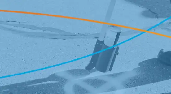
How Field Tools Generate the Highest Quality Data
This is where platforms like TerraFlow Mobile become critical.
When SUE professionals and locate technicians are in the field, they need tools that capture precise positions while they're actively investigating utilities. Not approximate locations based on historical records, but verified positions tied to actual electromagnetic detection or vacuum excavation.
TerraFlow Mobile integrates directly with GPS-enabled locators like the Radiodetection 8200SG and Vivax Metrotech RTK Pro. As technicians trace utilities, the system captures sub-meter GPS coordinates synchronized with their electromagnetic readings.
This generates records that are accurate, repeatable, and reliable—the cornerstone of quality utility data.
The system also captures depth measurements, photos showing site conditions, notes about surface features, and observations about discrepancies between existing records and field findings. All timestamped and georeferenced.
This level of detail simply isn't possible from desktop analysis.
And this is where the feedback loop begins.
High-quality field data captured through TerraFlow doesn't just document current conditions. It becomes the foundation for improving future records—including the datasets that desktop research platforms rely on.
The Complementary Workflow
Here's how these tools work together effectively:
Phase 1: Desktop Research
Use platforms like 4M Analytics to understand what utilities are likely present in your project area.
Identify potential conflicts early. Develop preliminary designs around known infrastructure. Scope field investigation requirements more accurately.
This reduces wasted field time. Instead of investigating entire corridors blind, your SUE teams arrive knowing approximately what they're looking for and where to focus efforts.
Phase 2: Field Execution
Deploy TerraFlow Mobile with GPS-enabled locators to capture precise positions during actual utility investigation and locating work.
Verify what desktop research predicted. Document discrepancies between records and reality. Capture new infrastructure that wasn't in historical records.
Generate comprehensive field documentation with photos, measurements, and georeferenced positions.
Phase 3: Records Integration
Feed high-quality field data back into enterprise systems—GIS platforms, CAD environments, work order management, and cloud-based records databases like TerraFlow's DataEngine.
This creates a feedback loop where field verification continuously improves the baseline data that desktop research platforms draw from.
Over time, this reduces the gap between predicted utility presence and actual field conditions.
Real-World Application: SUE Projects
Subsurface Utility Engineering follows defined quality levels specified by ASCE standards.
Quality Level D involves desktop research and existing records review—exactly what platforms like 4M Analytics excel at providing.
Quality Level C requires surface geophysical methods to verify utility locations. This is where GPS-enabled locating with TerraFlow becomes essential for capturing precise horizontal positions.
Quality Level B demands test holes to determine depth and verify utility characteristics. TerraFlow's ability to capture excavation data, photos, and measurements directly in the field ensures this information is documented accurately.
Quality Level A requires full exposure and mapping of utilities. Again, field tools capture the precise as-built conditions that desktop research cannot provide.
Desktop research accelerates the QL-D phase. Field tools with GPS integration are critical for QL-C through QL-A work.
Using both approaches together creates more efficient SUE workflows and higher-quality deliverables.
The Data Quality Difference
4M Analytics emphasizes their platform provides "AI-verified utility records and satellite imagery to validate and confirm findings visually in the field."
This is valuable for planning. But field professionals need more than visual validation.
They need to know that when they mark a gas line at a specific GPS coordinate, that position is accurate enough for excavation to proceed safely. They need depth measurements verified by electromagnetic detection or vacuum excavation. They need to distinguish active infrastructure from abandoned facilities.
TerraFlow generates this precision through direct integration with field equipment during actual utility investigation.
The difference matters when safety and liability are on the line.
Building the Continuous Improvement Loop
Here's where the real value emerges from using complementary tools.
As field crews capture precise utility positions with TerraFlow, that data flows back into enterprise GIS systems. Those same systems often feed data to platforms like 4M Analytics.
Over time, this creates a virtuous cycle:
Better desktop research narrows field investigation scope → More efficient field work captures precise positions → Improved GIS records enhance future desktop research → Repeat.
Each project contributes to more accurate baseline data for the next project.
This is particularly important in rapidly developing areas where infrastructure changes frequently. Desktop research might show historical utility positions, but field verification with GPS-enabled tools captures current reality.
That current reality becomes tomorrow's baseline data.
Practical Integration Points
For organizations using both types of platforms, several integration opportunities exist:
Pre-field planning: Use desktop research to identify investigation priorities and potential conflicts before mobilizing crews.
Field guidance: Import preliminary utility data into field applications so technicians can compare predicted positions against electromagnetic readings in real time.
Data reconciliation: Systematically compare field findings against desktop research predictions to identify patterns in data quality and update records accordingly.
GIS updates: Establish automated workflows where verified field positions update enterprise GIS, which then feeds improved data to research platforms.
Quality metrics: Track how often field verification confirms desktop predictions versus discovering discrepancies. Use this to refine investigation protocols.
The Bottom Line
4M Analytics is solving real problems in utility records research. Faster access to aggregated data genuinely improves project planning and reduces investigation time.
But desktop research and field precision serve different purposes in the utility management lifecycle.
Desktop tools excel at the planning phase—helping teams understand what's likely underground before they mobilize.
Field tools like TerraFlow Mobile excel at execution—capturing exactly what's there with the precision required for safe excavation and reliable records.
The tools are complementary, not competitive.
Organizations that leverage both—using desktop research to plan efficiently, then capturing field reality with GPS-enabled precision—generate the highest quality outcomes.
They reduce field investigation time while improving data accuracy. They build institutional knowledge that makes every subsequent project more efficient. They create records that serve both immediate operational needs and long-term asset management.
This is how utility management evolves: better planning tools working in concert with better field execution tools, both feeding data back into systems that improve over time.
Neither replaces the other. Both are essential for modern utility management workflows that prioritize safety, efficiency, and data quality.