POLE MAPPING
Pole mapping is the overhead capability in TerraFlow Mobile. The instrument is a laser rangefinder. How TerraFlow Mobile works
TerraFlow Mobile builds a full pole profile from a laser rangefinder, a GPS receiver and a tablet in one visit: height, class, attachments, clearances and span, with the position accuracy recorded for every measurement.
A profile you can engineer from Pole height and class, every attachment and its height, clearances, span lengths and guy positions. The detail make-ready analysis needs, not a photo and a note.
Measurements that show how they were taken Every position stores the GPS fix quality and accuracy at the moment of capture. Every laser measurement records the instrument and the method. When a joint-use dispute comes down to a clearance, the record shows how the number was got.
One visit instead of two Rangefinder, GPS and forms in the same workflow, so the crew gets everything the office needs the first time. The second trip is the expensive one.

The rangefinder measures it. TerraFlow records where.
A laser rangefinder gives you a distance and an angle. On its own, that's a number about a pole somewhere.
TerraFlow ties each measurement to the pole it belongs to and the position the crew was standing at, with the accuracy of that position recorded. Same job as every other TerraFlow capability, pointed at an overhead instrument.
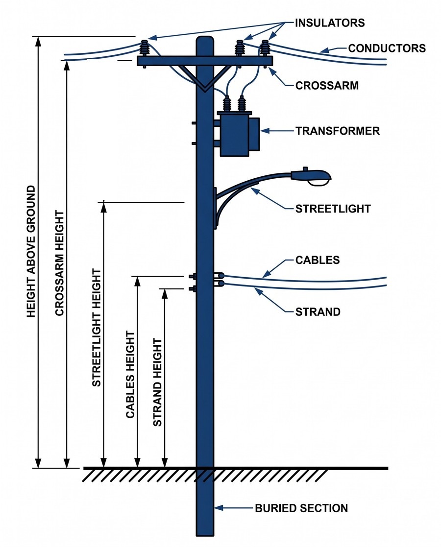
Illustration. Every attachment on the pole, with its height above ground.
Pole engineering and make-ready firms Field data detailed enough to run loading analysis without a return visit, exported to your pole engineering software.
Telecoms and broadband builders Attachment and clearance data captured the same way on every pole along a route, so permit packages come together instead of being pieced together.
Electric utilities and joint-use owners A current record of what's actually on your poles and who put it there, with the measurement conditions attached.
Works with your rangefinder and GPS
Rangefinder: Laser Technology 200x. GNSS receivers: Trimble R Series and Catalyst. Eos Arrow. Emlid Reach RS3. Juniper Geode. Bad Elf GNSS Surveyor.
Where the data goes
Records sync to Data Engine and export to your GIS, your CAD or your pole engineering software. REST API for anything else.
Specifications
Capture: point, line and polygon, with per-vertex detail. Attachment heights measured with the laser, using 3-point and 2-point missing-line routines. Text, dropdown and radio-button attributes. Photos. The user and a timestamp on every record.
Collection methods: a single point, timed points or lines that track the user, or points the user chooses one at a time.
Accuracy information per point: the GNSS metadata the receiver reports, including accuracy and satellites.
Hardware: Laser Technology TruPulse 200x over Bluetooth, and the GNSS receivers on the supported instruments list.
In the field: sketch from the captured data, and navigate back to any point.
Devices: Android and iOS.
Workflows and setup: your asset types, attributes, dropdowns and conventions, configured by us and managed through the web admin. Unlimited attributes.
Offline: works with no connection. Syncs when one returns.
Export: CSV, KML, Shapefile, ArcGIS Online and Portal, and DXF configured to your block and line standards. Import: DXF, KML, ArcGIS Online and Portal.
Deployment: hosted in Microsoft Azure with a separate database per client, or on-premises as TerraFlow Enterprise.
See a pole profile.
Tell us what you survey and which rangefinder your crews carry. We'll walk you through a real pole profile: every attachment, its height above ground, and the position accuracy of each measurement.